
ASAR GM Soil Moisture Product
Soil moisture products provide important information for understanding the state of the land surface when rainfall is expected. When soil moisture values are high, the ground may not be able to absorb heavy rainfall. It usually becomes run-off, which can cause flash flooding in localized areas and increase the water level in broader regions. In this section, we will look at three soil moisture products: ASAR GM, ASCAT, and SMOS.
The ASAR GM soil moisture product has been developed within the scope of the SHARE (Soil Moisture for Hydrometeorological Applications) project. SHARE is an ESA DUE Tiger project that provides an operational soil moisture monitoring service for user communities such as the Southern African Development Community (SADC), Australia, and portions of Argentina. Using ENVISAT's ASAR sensor, SHARE provides frequent (up to twice-weekly) high-resolution measurements of regional soil moisture dynamics. In particular, the data demonstrate the level of saturation of the upper 3 cm of the soil layer, with the values ranging from 0 (completely dry) to 100 (saturated). For more information, see http://www.ipf.tuwien.ac.at/radar/dv/asar/.
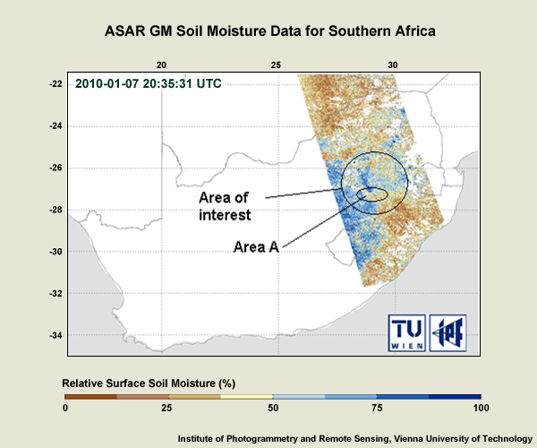
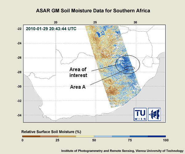
These ASAR GM soil moisture maps for the South African region show the percentage of soil moisture on 7 and 29 January 2010. On which day was Area A at a higher risk of flooding?
The correct answer is B.
The soil moisture values at area A ranged from 25% to 50% on 7 January and increased to 75% to 100% on 29 January. Clearly the area was at greater risk for flooding after 29 January if more rainfall hit the area, especially if it was heavy. You can see how ASAR GM data are useful complements to other types of data in heavy rainfall situations. Remember that whenever there's a risk of flash flooding, you should immediately issue a warning. Do so in consultation with the hydrological department if at all possible. If it's not possible, it is important to be be pro-active. Never assume that someone else will take care of the situation!