
ASCAT Soil Moisture Product
Polar-orbiting satellites equipped with scatterometers (special microwave sensors) provide useful information about land surface conditions since they measure global soil moisture values. Polar orbiters have relatively coarse spatial resolution (up to 12.5 km), but they scan almost all regions twice daily, providing data on a relatively frequent basis.
The ASCAT scatterometer on the MetOp polar orbiter takes direct soil moisture observations, which are converted into soil moisture products. These are available from EUMETSAT twice a day. Many environmental fields make extensive use of these products, including meteorology and weather forecasting; water management and drought monitoring; and crop yield forecasting. The data are also used by early warning systems. For more information on the product, please visit: http://www.eumetsat.int/Home/Main/DataProducts/ProductNavigator/index.htm and search for ASCAT soil moisture.
Here's an sample ASCAT soil moisture product from February 2007 over Europe. It shows the moisture content of 5 cm of the topsoil layer in relative units ranging from 0 (dry) to 100% (saturated).
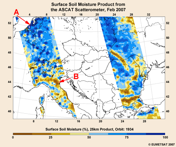
Which area has the highest soil moisture values and would be more prone to flooding if a heavy rainfall event occurred?
The correct answer is A.
Surface soil moisture values are at 100% in parts of the Netherlands, while the eastern coast of Italy has values between 0 and 25%. Based solely on this information, you can assume that areas with high soil moisture content are at a greater risk of flooding if a heavy rainfall event occurs.